

Dorian would touch Dominican territory as a category one hurricane on Thursday
The director of the National Meteorological Office (Onamet), Gloria Ceballos, reported that Dorian will be touching the national territory as a category one hurricane on Thursday morning and that during that day her presence would be felt, generating significant accumulated rainfall.
In a press conference at the National Palace, the expert, accompanied by other officials, specified that the accumulated rains would be between two and four inches, that is 50 and 100 millimeters and that the hurricane would have forces of 120 to 150 kilometers per hour .
“By Thursday at dawn it will already be southeast of the National territory (…). I would be touching national territory like a category one hurricane and going out in the northeast … that is, by Thursday we would be having the presence of this system throughout the day, ”said Ceballos.
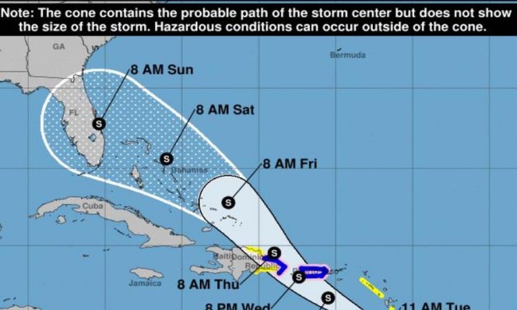
The 2:00 p.m. bulletin of the National Hurricane Center says that at that time the storm center was located at latitude 12.5 north, longitude 58.3 west, west / northwest with 22 km travel time and this movement is expected to continue until Tuesday night followed by a turn northwest on Wednesday.
In the forecast of the trajectory, the center of Dorian is expected to be near the Windward Islands in the afternoon and evening and moving east of the Caribbean Sea on Tuesday. “Dorian is expected to pass near or south of Puerto Rico on Wednesday and approach east of Hispaniola on Wednesday night,” said Ceballos.
Maximum sustained winds have increased to about 95 kilometers with higher gusts and a strengthening is expected over the next few days, says the National Hurricane Center.
The aforementioned agency also foresees that Dorian will be a hurricane when it moves near Puerto Rico and the east of the Dominican Republic.
Its winds with tropical storm force extend up to 75 kilometers from its center.
With information www.diariolibre.com


